Category

Digital Communities

“ESDN” Data Integration & Web-GIS Hosting

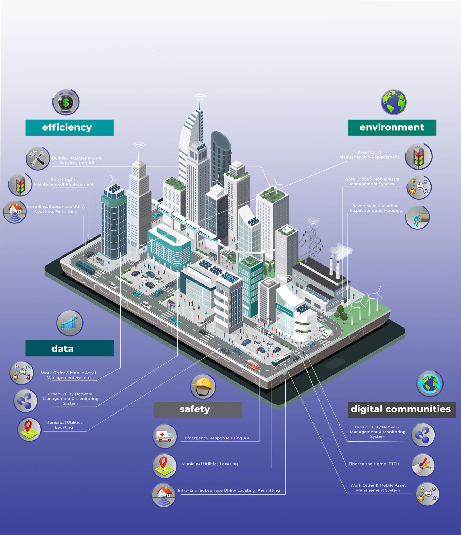
“ESDN (Electronic Spatial Data Network) is a multi-layer GIS engine, capable of supporting geo spatial data in both vector and raster form.  ESDN is a fully functional Asset Management System.”

Each asset can be associated with multiple schemas of metadata including both instantaneous and historical data. A variety of additional documents like images, PDF files, and other binary files can be attached to an asset. This is available instantly on the web interface or though the machine to machine (M2M) interface. ESDN has a diverse date importing and exporting options like ESRI shape files, DXF, KML and ASCII data, etc. Online, ESDN has an accompanying desktop version for ease manipulating spatial data.

ESDN can accommodate the integration of all geo-referenced urban assets that hold value for the Town into a single GIS system, by linking all infrastructure components that share a common location within an identified multi-layer base-map. The integrated Urban Asset Management system incorporates any existing information that can be used to support effective financial planning, preventative maintenance and risk management programs currently in place.

Good asset management can maximize the benefits provided by infrastructure as it deals with the long-term perspective. It also gives the Town the opportunity to achieve cost savings by identifying decline early on so action can be taken to rehabilitate or renew the asset, or related assets found within the infrastructure corridor.

“Archway” Augmented Reality (Patent Pending)

“Archway will reform building construction, maintenance, and repairs, as well as revolutionize emergency response.”

Archway (Patent Pendingis a cutting-edge system that allows users the ability to dynamically view each element of a structure. This technology has applications in building construction, building maintenance, as well as emergency response. It functions with two cases of structures: existing and new structure construction.

Augmented reality (AR) can dramatically change the way building construction, maintenance, and repairs are carried out, and emergency response is dramatically improved through infrastructure management. By mapping out what is behind each wall in a building, data can be integrated into applications for a number of uses.

Archway is comprised of a three-layer process:

1. Asset Development & Construction

2. Asset Maintenance & Repairs

3. Emergency Response with Augmented Reality (AR)

In layer 1, Asset Development & Construction, CAD Design files can provide the base for new project construction management. All building elements are imported into another system, called “INTUSLINK”, and itemized. “INTUSLINK” is the Operations Resource Planning (ORP) system which provides all work order functionality, partial completion project monitoring, cost management and inventory controls. The final deliverable of this layer is a 3D structure model.

In layer 2, Asset Management & Repairs, existing structures can be integrated into the Archway system by means of 3D laser scanner technology. Once a 3D model is created of a structure, all schematics of the building are integrated into the system. This includes: underground utilities, above ground utilities (in walls, etc.), doors, windows, and other important structural elements.

In layer 3, Emergency Response with Augmented Reality, all emergency related health & safety processes, evacuation pathways, exits and equipment operational manuals are included as assets in the final product. Upon completion of the project, a “24×7″ emergency response phone application, using AR tools can be downloaded by all structure/building employees and anyone visiting the structure. This application can be used to guide and assist anyone inside in case of emergency as well as emergency response crews.

Archway provides four key features:

  • Online Data Integrity & Security

  • Optimized Data Presentation

  • Additional Data Access

  • Data Organization

Online Data Integrity & Security:  Data is presented in interactive 3D environment, and only authorized users can view and edit data. Data is properly organized to maintain its integrity.

Optimized Data Presentation: Data is presented as layers, and each layer has its own presentation features which are customizable by member administrators. The layer presentation can be customized with respect to zoom level (i.e. different colour schemes for different zooms) and the amount of data downloaded is optimized for the field of view.

Additional Data Access: Authorized users can view and update the additional information of a particular object.

Data Organization: Data is properly organized in a hierarchy, composed of 1. Data Sets > 2. Layers > 3. Objects. Every member can control the layers, data in layers, data sets and layers in data sets.