Category

Data

“24×7” Emergency Response with AR

“24×7 Is An Auxiliary System And Supporting Group That Assists Local Emergency Responders During Natural Disasters And Terrorists Attacks.”

The Approach

  • Immediate Migration of Infrastructure Data (preferably GIS Data) into a Remote Server accessible by Cloud Technologies.
  • Immediate migration of all Infrastructure Safety and Operations Training manuals on Cloud.
  • Provide Hand Held devices to all responders for viewing all GIS and Safety Procedures on a Geo-location model, with enabled two-way communication via these devices for full scale reporting from the field. (Damages, casualties etc.)
  • Implement GPS technology to all First Responders vehicles.
  • We can provide portable Emergency Response Center technologies and operational personnel
  • We can provide underground utility locators with Fault detection instrumentation to locate the damaged utilities. (power, telephone, fiber etc.)
  • We can provide Utility Repair personnel for immediate restoration of power, telephone, and internet in support with local utilities especially on high priority buildings (hospitals etc.).
  • We can involve 24×7 in advance of any situation by transferring Infrastructure Data into GIS and Web GIS.
  • We can integrate Building Infrastructure Plans and provide Emergency Exit Instructions visually on Android Hand-held devices.
  • 24×7 RRR will be extremely valuable instrument during restoration of infrastructure.

“ESDN” Data Integration & Web-GIS Hosting

“ESDN (Electronic Spatial Data Network) is a multi-layer GIS engine, capable of supporting geo spatial data in both vector and raster form.  ESDN is a fully functional Asset Management System.”

Each asset can be associated with multiple schemas of metadata including both instantaneous and historical data. A variety of additional documents like images, PDF files, and other binary files can be attached to an asset. This is available instantly on the web interface or though the machine to machine (M2M) interface. ESDN has a diverse date importing and exporting options like ESRI shape files, DXF, KML and ASCII data, etc. Online, ESDN has an accompanying desktop version for ease manipulating spatial data.

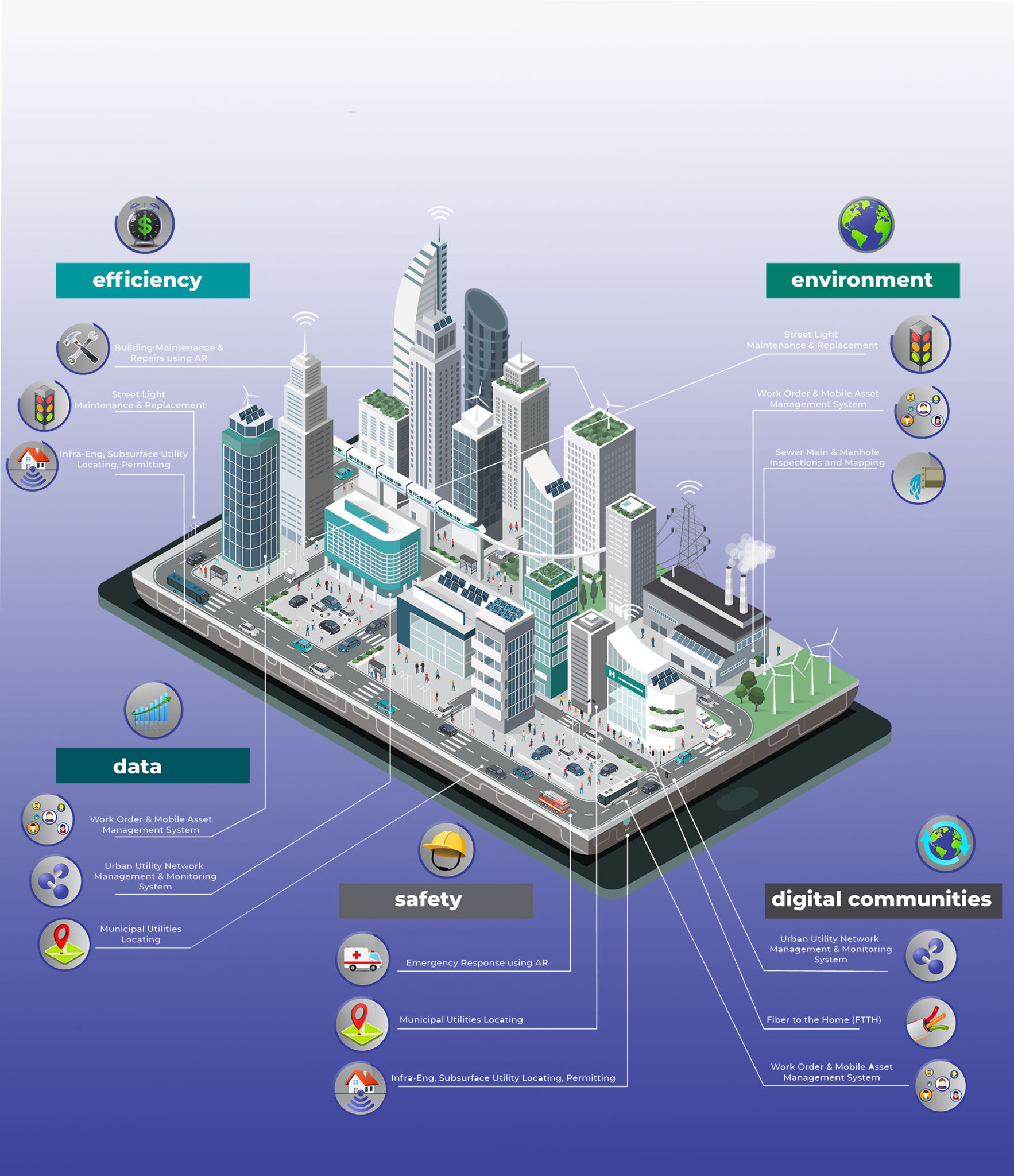
ESDN can accommodate the integration of all geo-referenced urban assets that hold value for the Town into a single GIS system, by linking all infrastructure components that share a common location within an identified multi-layer base-map. The integrated Urban Asset Management system incorporates any existing information that can be used to support effective financial planning, preventative maintenance and risk management programs currently in place.

Good asset management can maximize the benefits provided by infrastructure as it deals with the long-term perspective. It also gives the Town the opportunity to achieve cost savings by identifying decline early on so action can be taken to rehabilitate or renew the asset, or related assets found within the infrastructure corridor.

“INTUSLINK” ORP System

“INTUSLINK and Archway work hand-in-hand to advance construction and asset development & management.”

INTUSLINK is an Operations Resources Planning (ORP) system for asset development, construction and asset management. The system facilitates real-time field reporting tools including online progress reports on partial completion of projects, as well as supports the integration of elements such as repair records and associated maintenance costs.

INTUSLINK has multiple build-in modules such as:

  • Inventory Mobile Asset Management
  • Field Crew Scheduling
  • Performance & Cost Tracking
  • Network Asset Management Permitting
  • And more, all visually accessible via an advanced AR environment

INTUSLINK provides state-of-the-art progress reporting.

“INTUSlink” allows for online partial completion and progress reports for each project and enables management to efficiently monitor productivity, budget & timelines at all times through the construction & asset development layer. Work progress can be displayed on a GIS or AR environment while automated notifications can be activated for each task or group of tasks. Labor and other associated cost figures and percentages are available and can be shared with management to allow for an effective cost control.